|
things to do ->
|
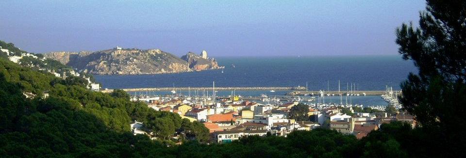
Beaches and coves |
|
The municipal area boasts about 15 km of
long, varied coastline, with 5.4 km of beaches and 9.7 km of rocky
shores. Visitors to l’Estartit will find shallow, sandy beaches with a
wide range of services for families on holiday. The small coves around
the Montgrí coast, accessible only by foot or boat, are ideal for
enjoying a quiet diving in peaceful surroundings.
Long beach divided into three sections: the
main beach 1 km, Platja dels Griells 0.5 km and Platja de la Pletera 1.8
km. Swimming areas and sports areas are well cordoned off with buoys.
The beach has fine sand and shallow waters. |
|
Main beach
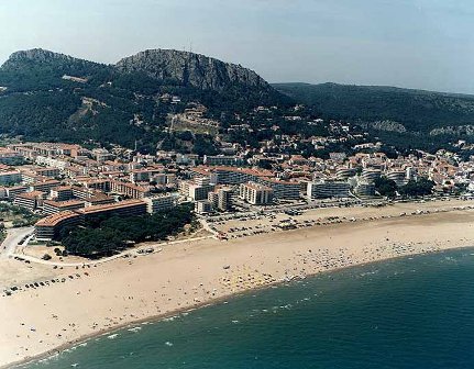
The most popular bathing place, situated just opposite the main
residential area in l´Estartit.
Plane |
|
Platja de Griells
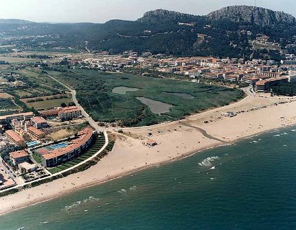
Quieter beach situated between Els Griells housing estate and the
pleasant surroundings of ter Vell Natural Reserve at the lower end. The
major water sports companies operate from this beach.
Plane |
|
Platja de la Pletera

The least developed and least crowded stretch of beach. Together with
the Ter Vell Natural Reserve, it is included in the Baix Empordà
Wetlands dunes and lagoons restoration project. Difficulty of access
makes this a peaceful, uncrowned spot, in a site of great natural
beauty. natural.
Plane |
|
Platja amenities
· Showers, litterbins, beach cafes, deckchair and sunshade rental, pedal
boats and pleasure boats
· Water sports: water skiing, ski bus, kayaks, sailing school,
windsurf...
· Esplanade and car park
· Marina
· Beach cleaning
· Supervisors, lifeguard and rescue service, first aid, amphibian chairs
· Medical care |
|
Platja de Mas Pinell

5 km as the crow flies and 13 km by road
from l’Estartit. Access by car to this 1,3 km sandy, standard depth
beach.
Plane |
|
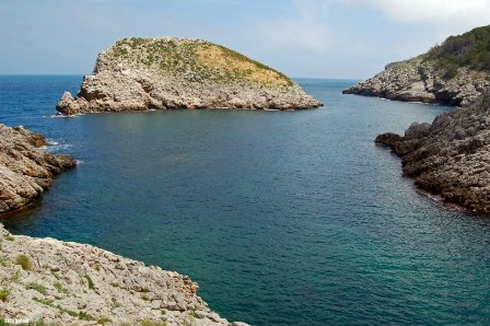
Cala Montgó

The main geographic feature along the whole
of the Montgrí coast, with a round shape suggesting the existence of an
original sunken dolina, flooded and enlarged by the sea. Archaeological
excavations have shown that the Romans used Cala Montgó as a landing
place. The cove is situated 20 km by road from l’Estartit and 12 km by
mountain tracks. Access on foot, by car, bicycle or boat. Swimming area
and sports areas marked by buoys. Cala Montgó is 600 meters long.
Plane |
|
Cala Ferriol

Second largest cove on the Montgrí coast
after Cala Montgó. 45-minute access by foot, after leaving the main
track.
Plane |
|
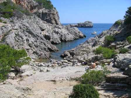
Cala Pedrosa
Small sheltered cove set in heavenly
surroundings among rocks and pine trees that invite bathing in summer
and peaceful contemplation of nature in the winter months, with the
picturesque Pedrosa islet completing the beauty of the scene. 30-minute
access by foot, after leaving the main track.
Plane |
|
Cala Calella
Small rocky cove situated at a 30-minute
walk from L’Estartit harbor along a track with magnificent vistas of the
Medes Islands from the viewpoint at Els Arquets. The track leads past a
curious geological sea well called Pou de la Calella.
Plane |
|
The Montgrí coastline

One of the most rugged, unspoilt parts of
the Costa Brava, running from Cala Montgó to L’Estartit past the Montgrí
Massif cliffs, past the Ferriol, Falaguer, Pedrosa and Calella coves and
the Milà, Castell and Barra promontories. The highest cliffs are 100
meters tall; Roca Maura and Torre Moratxa spurs stand at a towering 200
meters each. The coast is full of interesting nooks and crannies, such
as La Foradada rock, and the rich, protected seabed is a divers’
paradise.
Plane |
|
Medes Islands |

Situated in the heart of the Costa Brava, the Medes Islands constitute
one of the principal marine flora and fauna reserves in the Western
Mediterranean, a privileged natural area for visitors to this area and a
much appreciated scuba-diving destination.
The archipelago covers an area of approximately 23 hectares and is
situated a mile off the Costa Brava, just opposite L’Estartit beach. The
Medes Islands are a set of seven islets called La Meda Gran , La Meda
Petita , El Medellot (or La Bota ), El Carall Bernat, Les Ferranelles,
Els Tascons Grossos and Els Tascons Petits. The Medes Islands were
listed as a marine reserve in 1983 and since then the area has seen a
spectacular recovery of the rich seabed and of many sea and land species
previously in danger of extinction. The pleasure of diving and boating
around this beautiful seascape is thus enhanced making this an ideal
place to spend a holiday.
The Medes Islands ecosystem is deservedly classified as the best natural
reserve in the western Mediterranean. The diversity of depths provides
dives for all levels. In the shallow areas we find a dense mantle of
well-lit seaweeds and over a hundred brightly colored species. At depths
below 10-15 meters we find light-deprived seaweeds, great rocks
surrounded by coral, starfish, gorgonia, octopus and lobster. Below 20
meters we enter a darkness of coral and miniature forests of bright
colors inhabited by over 600 species of fauna. The different depths
provide diving opportunities for everyone from professional divers to
absolute beginners, and all will enjoy the colorful spectacle of
underwater marine life.
Numerous caves and tunnels indicate that the limestone archipelago was
attached to the Montgrí Massif over ten thousand years ago. Nowadays
caves around the Medes Islands and the Montgrí coast provide outstanding
opportunities for expert divers: Vaca, Sardina, Dofí Nord caves and
Pedrosa tunnel, among others.
Near the islands we find the Reggio Messina, the largest ship that
divers can visit on the Costa Brava, sunk deliberately in 1991. The
Avenire, also known as the Marmoler, sunk near Cala Montgó cove in 1971
with a cargo of marble in its hold, is the only wholly conserved
underwater ship in the area.
Plane |
|
Some history
The islands are uninhabited today but shipwreck remains testify to
ancient Greek ships navigating these seas in classical times. Findings
of lachrymatory phials and human bones suggest that the islands may have
been used as a necropolis. In the 15th century, a fortress was
constructed on La Meda Gran , and inhabited by the knights of St.
Sepulcher. The monks eventually left and the fortress partially caved in
after numerous pirate attacks in the 16th century. Throughout the 18th
century wars the fortress was used as a prison and later as a military
garrison until 1890. Today the Medes Islands are uninhabited. |
|
The lighthouse
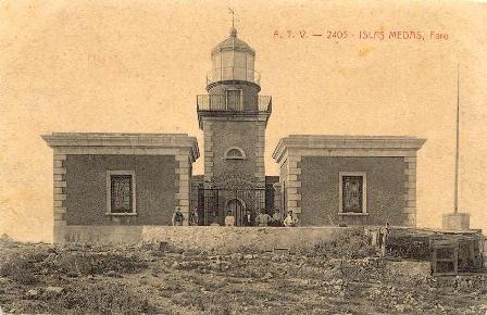
The first lighthouse was built on La Meda Gran in 1866, during the reign
of Isabel II and was tended by a resident lighthouse keeper until 1930.
The new automatic lighthouse is now powered by solar energy.
|
|
Vegetation
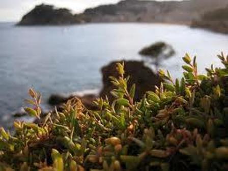
The Mediterranean climate includes long periods of drought often
coinciding with the heat of the summer. The dry land cannot then easily
absorb water and, when it rains, a lot of the water slips away through
the cracked earth. In response to this, plants like the prickly pear and
the rest harrow contain water reserves that enable them to survive in
the driest places. The prevailing Tramuntana north wind and Garbí south
west wind carry drops of salt sea water to the islands, where the
vegetation includes shrubby sea-blight plants that eliminate excess salt
through their leaves. Caucus gingili and rock sapphire are other
salt-resistant plants.
On the other hand, the island flora was modified by man by the
introduction of exotic species such as agaves and the tree of heaven.
Another factor is the huge quantity of gull-produced dung that
fertilizes the islands and allows abundant mallows and other wild
species to thrive. |
|
Faune
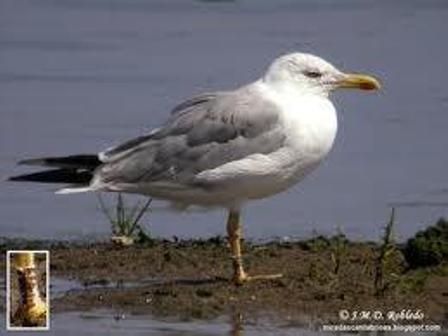
The yellow-legged gull is undoubtedly the most common species on the
Medes Islands, home to the largest colony in the Mediterranean. However,
the sheer numbers of gulls may mask the presence of other interesting
bird species, such as the large colony of ardeidae (cattle egrets,
little egrets and night herons), the second largest of its kind in
Catalonia. On the islands we also find peregrine falcons, pallid swifts,
alpine swifts and blue rock thrush, among other bird species, and in the
rock pools there is a small colony of common European shag.
Nevertheless, it must also be said that the true inhabitants of the
islands are the many different species of insect, with the mallow bug as
the most significant.
The Medes Islands and the Montgrí Massif are both part of the same
geological unit. |
|
The Montgrí |
|

Three mountains make up the Montgrí Massif,
the emblematic backdrop to the town of Torroella de Montgrí and
epicenter of the two Empordà counties: Puig Anill (or Ullà Mountain)
with an altitude of 309 meters; the Montgrí Mountain with an altitude of
303 meters, crowned by a 13th century castle overlooking the whole
Empordà region; and Montplà with an altitude of just over 300 meters.
The Massif covers an area of over 2,300 hectares, and has a total length
of about 8 kilometers, with spurs reaching right down to the 200-metre
Roca Maura and Torre Moratxa rocks at L’Estartit.
Plane |
|
Santa Caterina hermitage
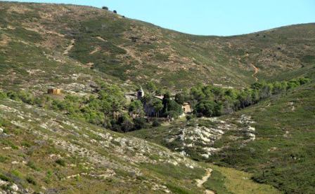
The hermitage was founded in the 18th century by three friars from
Montserrat monastery called Tarascó, Desgell and Cabotes (1) and is
situated in Santa Caterina valley in the heart of the Montgrí Massif.
There is a small chapel on the ground floor, living quarters formerly
occupied by the hermit’s family on the first floor and old storerooms in
the basement. Local children used to believe that babies came from the
well in the courtyard of the hermitage.
An outdoor gathering is held here every year on 25th November in honour
of Santa Caterina who, according to a 17th century tradition, is
attributed with saving Torroella from a year of hunger and plague. Local
people walk up to the hermitage from Torroella following the Path of the
Chapels, up to a large cross on the shoulder of the mountain and from
there down on into Santa Caterina valley. Access by car is from a track
opposite Bellcaire village.
(1)An illustrated tale on Santa Caterina hermitage written by Joan
Pericot in 1955 and republished in 1980 evokes a spring with cool, clear
water called Aribosa and recalls a popular verse in homage to the saint:
"En tempesta marinera,
en naufragi o malaltia,
oh, santa d’Alexandria!
sou la millor remeiera."
Plane |
|
The path of the chapels
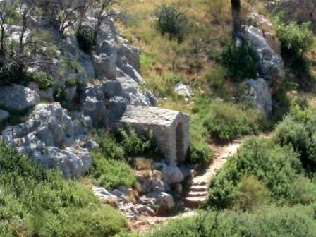
The path
up to Montgrí Castle leads past three ruined chapels, two on the right
and one on the left, used as a resting place by pious devotees on their
way up to Santa Caterina hermitage and by local shepherds as a shelter
from inclement weather conditions. The chapels are stone constructions
with vaulted roofs.
Plane |
|
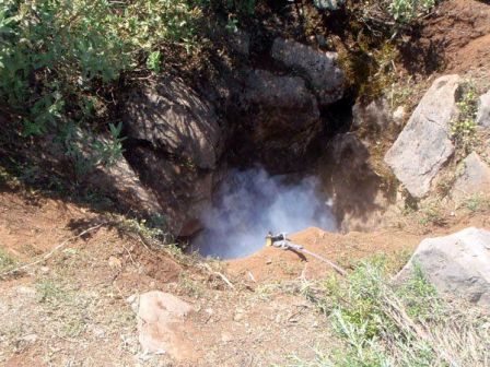
Cau del Duc cave

The cave is situated 200 meters above sea level on the south face of the
Montgrí Massif and was formed by water filtrations dissolving the
limestone. "Cau del Duc" means "Cave of the Eagle Owl", a bird of prey
that formerly nested in the Montgrí.
Probably due to its strategic situation and the shelter afforded from
the Tramuntana north wind, the cave was inhabited by man some 300,000
years ago during the Lower Paleolithic age.
Plane |
|
The Montgrí castle
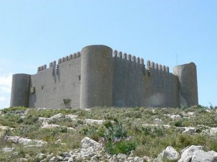 Construction of Montgrí Castle, the symbol of Torroella, was ordered in
1294 by King Jaume II as the result of a confrontation with the Earldom
of Empúries, but work was interrupted in 1301 and the building left
unfinished. Four walls were raised forming a square, with a tower built
into each corner. Restoration work was carried out in 1988.
Access on foot is from Torroella, along a signposted mountain track (GR
92).
Plane |
|
Santa María Palau hermitage

This ruined 13th century Romanesque hermitage overlooks Sobrestany, on
Muntanya Gran.
Plane |
|
The Dunes
Sandy dunes situated on the path leading to the summit of Muntanya
Gran. The dunes were planted with grasses and pinewoods in the early
20th century in order to stabilize the sand blown in from Roses Gulf by
the Tramuntana north wind, and thus protect the surrounding vineyards
and vegetable gardens.
Plane |
|
Caves, rock pits and shelters
Some fifty caves and rock pits are known to
exist throughout the mountain range, notable among them being Cau dels
Ossos, where archaeological remains from the Neolithic period were
found, Avenc de l’Hostench, La Carnisseria system, and so on. We also
find dry-stone walls and huts used for sheep and as shelters for
shepherds, of which the best preserved is Aixart d’en Vidal. A whole
cultural heritage is there to be explored.
Plane |
|
The castle of Montgrí |
|
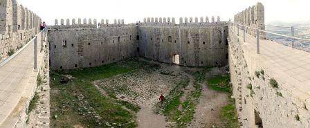 Symbol of Torroella, Montgrí Castle is
situated at the summit of Montgrí Mountain, commanding a magnificent
panoramic view of Canigó, Gavarres and Montseny mountain ranges and of
the Mediterranean Sea with the Medes Islands in the foreground. Symbol of Torroella, Montgrí Castle is
situated at the summit of Montgrí Mountain, commanding a magnificent
panoramic view of Canigó, Gavarres and Montseny mountain ranges and of
the Mediterranean Sea with the Medes Islands in the foreground.
In the year 1272 Torroella de Montgrí was proclaimed a royal town thus
providing the crown with a major possession very near the Earldom of
Empúries, with which it had been at war for many years.
In 1294, as a result of the confrontations, King Jaume II ordered the
construction of a castle at the summit of the Montgrí as a fortress to
protect his dominions from Empúries. The conflict continued until 1325,
when Count Hug VI of Empúries exchanged lands with Pere, the infant son
of Jaume II.
Construction work was carried out on the castle between 1294 and 1301
and was then discontinued. Four 31-metre long perimeter walls were built
around a square floor plan, with a cylindrical tower in each corner. The
four wings of the castle were never completed. The walls are 13 m high
and are surmounted by square, pyramid topped battlements with loopholes
at the base.
Plane |
|
Situation: Summit of the Montgrí
Massif, at an altitude of 302 m.
Walls: 31 m long and 13 m high, surmounted by square, pyramid
topped battlements with loopholes at the base.
Towers: Cylindrical, with three levels in the northwest tower and
two levels in the other three.
Façade: South-facing, with arched voussoir entrance gate.
Interior: Square-plan, stone-paved central courtyard constructed
over a large water cistern.
Restoration works: Consolidation of parts of the wall, addition
of a spiral staircase inside the northwest tower, construction of a
walkway around the battlements, with safety handrail.
Other constructions: Remains of walls on the south façade, water
cistern on the north façade.
Architectural style: Transition period between Romanesque and
Gothic. |
|
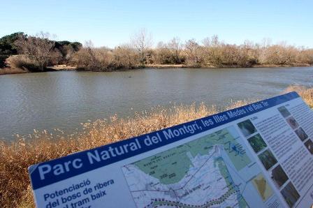
Wetlands |
|
Geographic situation
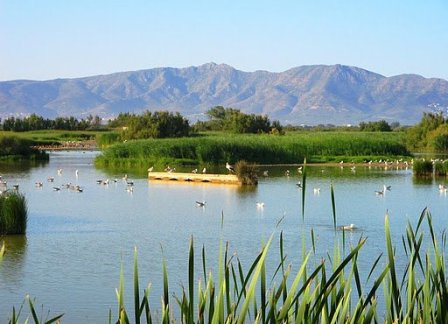
The Baix Empordà wetlands are situated near the coast on the delta of
the Ter and Daró rivers, between L’Estartit and the Montgrí Massif in
the north and Pals and Begur Massif in the south. The wetlands comprise
the Ter Vell, La Pletera , La Gola del Ter, La Fonallera and Les Basses
d´en Coll marshes.
Plane |
|
Excursions |
|
Walks
Cala Calella, Cala Pedrosa, Cala Ferriol,
Cala Montgó, Les Maures, La Resclosa, Montgrí Castle, Santa Caterina
hermitage and the Dunes, left bank of the River Ter and the beach |
|
Bike trips
Baix Ter plain, right bank of the River Ter, Muntanya Gran, L’Estartit
and La Gola, Torroella - L’Estartit old road. |
|
Excursiones marítimas
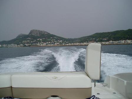
An ideal activity for the whole family! On
some of the local boat trips you can stop and have a dip in the sea.
|
|
Nautical activities |
|
In L’Estartit you will find a wide range of
nautical options to choose from.
Individual activities plus activities for the whole family, suitable for
all ages and skills. |
|
Scuba diving
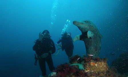
L’Estartit is a scuba-diving paradise. In the Medes Islands natural
reserve and off the Montgrí coast there are over twenty dives for both
professionals and absolute beginners. |
|
Snorkelling
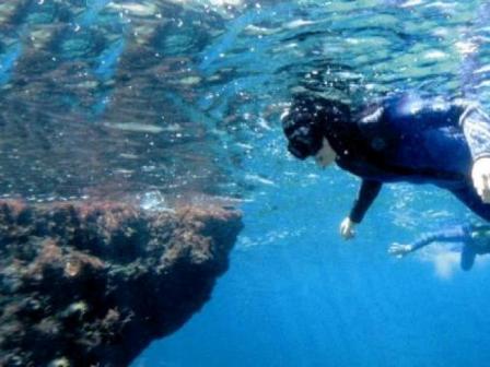
Snorkelling is another underwater activity to explore the seabed in a
different way, guided by a professional monitor. |
|
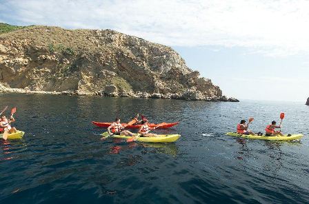
Kayaking
 |
|
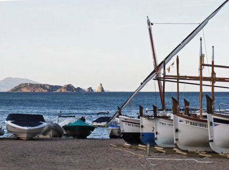
Boats to rent
Boat hire is another nautical activity that will make your holiday
all the more enjoyable. |
|
Sailing

Take the opportunity to go sailing in L’Estartit and to learn sailing
techniques from professional instructors. |
|
Windsurf
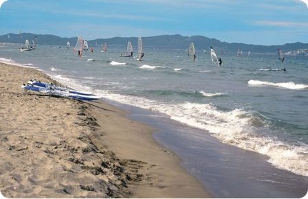
Make the most of the gentle summer breezes and enjoy a different type of
sea experience. |
|
Kitesurf
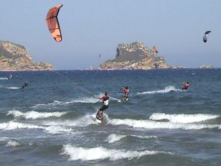
Make the most of the gentle summer breezes and enjoy a different type of
sea experience. |
|
Land activities |
|
Another way to spend an enjoyable holiday is
to partake in activities that will bring you into closer contact with
the land itself.
There is a wide range of sports on offer that will enable you to explore
and get to know the local surroundings during your holiday |
|
Horse riding
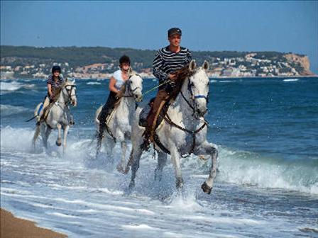
Enjoy our landscape in a different way. |
|
Golf
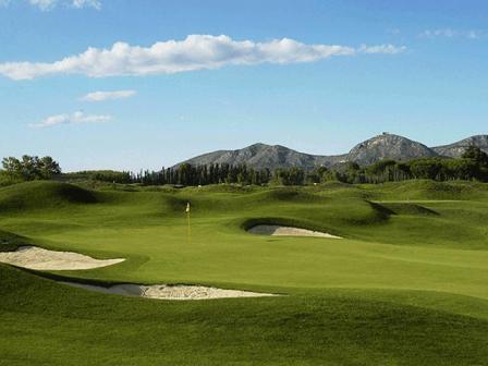
It is easy to get a game of golf and to learn to play this sport in an
area that is well known to golf-lovers. |
|
Tenis

Enjoy a game of tennis on top-class courts in peaceful surroundings. |
|
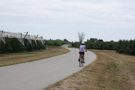
Ciclismo

An ideal place for cycling, both road and mountain. |
|
Go-Karts
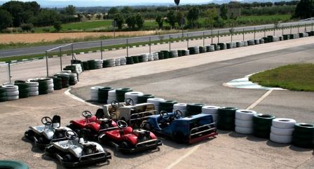
For those who want something different, go-karting is the sport for you. |
|
Other sports
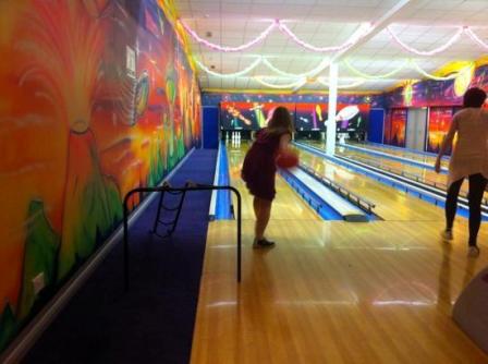
You will also find different sports to enjoy your free time differently.
Bowling, football, gym ... |
|
Air activities |
|
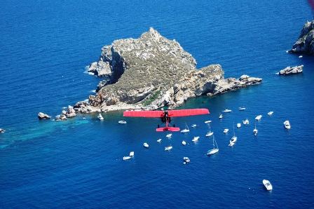
What about going flying up there in the blue sky? Try
something different and explore the area from another, exciting
perspective. |
|
Torroella y L'Estartit todo el año es
un programa de visitas para grupos y en fines de semana que engloba |
|
- Descubre el Mediterráneo a través de
los cinco sentidos: visita al Museo del Mediterráneo
- Las islas Medes, el tesoro del Mediterráneo: Visita al museo del
Mediterráneo, excursión a las islas Medes y descubrimiento del fondo
marino
- Torroella de Montgrí, mil años de historia y leyenda: visita al
Museo del Mediterráneo y recorrido por el casco antiguo de Torroella de
Montgrí
- El emblema del Montgrí: Excursión al castillo medieval del
Montgrí
- El paisaje de una arquitectura humilde: Ruta a pie por el macizo
del Montgrí descubriendo el patrimonio de la piedra en seco
- El valle rodeada de Sol soledad. Excursión
al valle y la ermita de Santa Caterina recreando la novela de Víctor
Catalán
- Donde la flora acoge la fauna: Visita a los humedales del Baix
Ter
Las visitas se pueden hacer en diferentes
idiomas: catalán, castellano, francés e inglés. |
|
Museums |
|
CAN QUINTANA-MUSEU DE LA MEDITERRÀNEA
Can Quintana, one of the most noteworthy
historical buildings in Torroella, now houses a new museum dedicated to
the human space of the Mediterranean area, based on local territories:
the Montgrí Massif, the Baix Ter plain and the Medes Islands.
A hands-on museum for all ages that brings us closer to the aromas of
the Mediterranean, invites us to listen to its sounds and its music and
to explore the history of the area. A panoramic audiovisual brings us in
touch with the reality of the Mediterranean today.
The centre has an interesting agenda featuring temporary exhibitions, as
well as a programme of cultural, social and musical events. Guided
visits around the museum and outside are available all year round |
|
PALAU SOLTERRA – FUNDACIÓ VILA CASAS
Exhibition of contemporary photography from
the collection. Temporary monographic exhibitions. Lectures, concerts,
guided visits by appointment. |
|
PALAU SOLTERRA – FUNDACIÓ
VILA CASAS |
|
MICHAEL DUNEV ART PROJECTS
An international contemporary art gallery with monographic exhibitions
by well-known artists, located in a restored 17th century house in the
historic centre of Torroella. |
|
ATRIUM
ATRIUM displays the works of visual artist Joan Carles Roca Sans in
exhibition rooms surrounding the gothic courtyard of the former Casa
Quintana-Badia, in the historic centre of Torroella de Montgrí. ATRIUM
is a space for critical reflection. |
|
Exhibition rooms |
|
SANT ANTONI CHAPPEL
Temporary exhibition room. |
|
HOSPITAL CLOISTER
Monthly photography exhibitions. |
|
LOCAL COUNCIL
Temporary exhibition room. |
|
The international music
festival |
|
International music festival
One of the major summer musical events in
Catalonia and well-known all over Spain, the International Music
Festival annually hosts some twenty concerts and recitals performed by
prestigious soloists and groups. The programme offers chamber music, in
formations ranging from duets to full orchestras, symphonic and sacred
music, jazz and world music.
The concerts usually take place in the Church of Sant Genís, which is
acoustically equipped for each different event.
Some Festival concerts are held in the open air on the Plaça de la Vila,
as are the concerts performed by students taking part in the
international music summer school held alongside the Festival. Classes
are conducted in a former Augustinian convent in Torroella, now the
Anselm Viola International Music Academy |
|
Fairs and markets |
|
Every Monday morning, a huge market sprawls
over the streets in the old town of Torroella de Montgrí, with stalls
selling fruit, vegetables, clothes and many other products. The
traditional weekly market is also a gathering place for local farmers
and stockbreeders who meet to buy and sell goods and exchange
information.
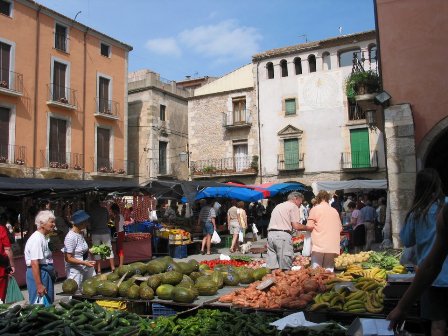
In L’Estartit there is also a weekly market every Thursday between the
Passeig Marítim and the Avinguda de Roma, with a large and varied
display of goods for sale.
Torroella de Montgrí also hosts one of the main agricultural,
stockbreeding and trade fairs in the area. The Saint Andrew’s Day Fair
is held annually on the last weekend in November.
The Medes Island Image and Environment (MIMA) Festival in L’Estartit has
become one of the best-known underwater image festivals in Catalonia.
This year the festival will take place from 6th - 10th June. |
|
Events |
|
 view upcoming events
 |
<- things
to do

|
|